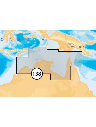
NAVIONICS PLATINUM PLUS NORTHERN TERRITORY MARINE CHART CARD
Description
Head out with confidence! All the same marine and lakes content and advanced features found in Navionics+ for GPS plotters are augmented with 3D View, satellite overlay and panoramic photos to provide the ultimate situational awareness. Designed with the most demanding boaters in mind, these additional viewing options can be used on a growing number of GPS plotters.
We make thousands of edits every day, so you can always have the most current charts.
Daily updates and advanced features are included for one year.
 Satellite Overlay Platinum
  3D View Platinum
 Panoramic Photos
  Nautical Chart
 SonarChart™
  Community Edits
 Daily Updates
  Dock-to-dock Autorouting
 SonarChart™ Live
  Advanced Map Options
 Plotter Sync
Shipping and returns
Shipping and customer service
We use Australia Post Eparcel for shipping if goods within Australia. If you would like to use an alternative shipping method please Contact Us and we can discuss alternatives.
When you contact us, a real person will call you back! This is what separates us from our competitors. We are a real store on QLD's Gold Coast with over 30 years experience in boating and Customer care.
Returns policy
We have a 30-day return policy, which means you have 30 days after receiving your item to request a return.
To be eligible for a return, your item must be in the same condition that you received it, unworn or unused, with tags, and in its original packaging. You’ll also need the receipt or proof of purchase.
To start a return, you can contact us at chandlery@bosuns.com.au. If your return is accepted, we’ll send you a return shipping label, as well as instructions on how and where to send your package. Items sent back to us without first requesting a return will not be accepted.
You can always contact us for any return question at chandlery@bosuns.com.au.
Have a question
PO Box 138, Main Beach QLD 4217
Street Address:Southport Yacht Club, Macarthur Parade, Main Beach QLD 4217
Trading HoursMonday - Friday - 7.30am – 5pm
Saturday - 8am to 4pm
Sunday - 8am to 12noon
(07) 55 911 911 | Fax (07) 55 916 147
Email: